Based on the work undertaken during the previous mandate within an overarching process of generating knowledge, in 2015 the drawing up of the Metropolitan Urban Master Plan (PDU) got underway. The Directorate of Urban Development Services provided the Master Plan with a Drafting Service which developed the thematic writing committees of the urban development guidelines during this period and devised the foundations and structure of the drafting process, which resulted in the studies presented in the PDU Proposal.
Beyond this document, the Directorate of Urban Development Services has continued its cooperation and technical, legal and economic assistance for the metropolitan municipalities on matters of planning, action programmes and projects. In this period, studies, reports and planning and urban management documents were drawn up, and support programmes were defined and developed.
None of these tasks would have been possible without sound baseline information and studies in different fields which provided knowledge on the metropolitan reality. In this four-year period, databases were improved and new ones developed, along with an entire series of studies which are providing us with an increasingly complete and broader vision of the region as a whole which were primarily used in drawing up the metropolitan PDU. Likewise, we should also highlight the consolidation of mapping and planning portals as tools used by technicians and citizens on a daily basis.
On the other hand, the Directorate has also consolidated the processes that enable it to exercise its authorities, which include the initial and provisional processing of the urban plans of metropolitan interest or that affect more than one municipality, developing the mandatory reports to authorise uses or provisional projects, protection of the urban development laws and technical participation in the Regional Urban Development Commission of the Barcelona Metropolitan Area.
-
The Metropolitan Urban Master Plan. The PDU Proposal
In 2015, efforts began to draw up the Metropolitan Urban Master Plan (PDU) based on the studies conducted in the two previous years within the process of generating knowledge. Three years later, after the process of drawing up the PDU had begun, the Metropolitan Council approved the public exposure of the documents comprising the Proposal in its session held on 25 March 2019.
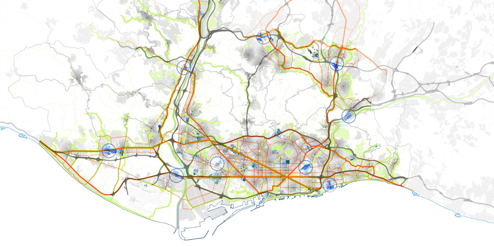
Along with the Metropolitan Urban Planning Plan, the PDU is the integrated urban planning instrument of the metropolitan area of Barcelona. Therefore, it is essential in dealing with and overcoming many of the shortcomings and deficits in this region, in guiding the transformations it requires and in anticipating future challenges and needs. Bearing in mind the thematic and regional diversity, in view of the sensitivity towards the entire set of agents and institutions that comprise it, the process of drawing it up was appropriated in an open, participative way from the start. For this reason, there are many different agents and mechanisms of participation that have taken part from the very beginning.-
The process of drafting the Plan
With the exhibition "Metropolis Barcelona", the previous phase is concluded and the phase in which the PDU is actually drawn up begins. This is marked by the creation of the PDU Drafting Service within the Directorate of Urban Development Services, the development of the thematic writing committees of urban development guidelines and the development of the foundations and structure of the process.
The purpose of the thematic committees was to specify the level of reflection in terms of the crucial strategic aspects in the current urban planning. In this sense, eight thematic writing committees were developed on urban metabolism, mobility, green infrastructures, areas of innovation and centrality, economic activity areas and residential neighbourhoods.
A group of experts on the particular matter work together on the committees to formulate an agreed-upon document with urban development guidelines, after having first held debates and drawing up transversal, complementary studies which analysed, evaluated and suggested the best alternatives for the phenomenon studied. More than 400 experts from multiple disciplines, both professional and academic and institutional, participated in this process.
The development of the foundations and structure of the drafting process meant defining the roadmap for the implementation of the process, with the consequent creation of different committees, both institutional and technical. The prime goal was to guarantee the town halls' participation in drawing up the plan, which is not limited to the issues that directly affect the respective municipalities but also entailed true co-authorship of the entire set of proposals.
In this sense, over the past year and a half numerous sessions of these committees have been held to develop and track the work associated with drawing up the PDU, both political committees with the Governing Commission and the Information Commission of the Metropolitan Council, and technical ones, where the Technical Direction Commission was included, along with the four committees made up of the metropolitan town halls (that is, the Barcelona town hall and the town halls of the municipalities within the Vall Baixa and Ordal-Garraf, Llobregat and Nord, and Vallès), the Technical Working Commission with the Government of Catalonia and the committees with other institutions to carry out specific jobs. -
Dissemination
Parallel to the drafting of the Plan, from the very start the Barcelona Metropolitan Area has shown a special interest in disseminating the work that has been done to both the expert and general public.
In this sense, three particularly significant initiatives are worth highlighting. The first is the continuation of the Quaderns_PDU Metropolità collection as a platform for disseminating the knowledge generated. The collection consists in 16 issues, the first eight the outcome of the workshops held between 2013 and 2015, as well as other studies conducted throughout this period, and the next eight geared as urban development guidelines developed by the thematic committees.
These paper publications may be consulted and downloaded on the platform, which is the second dissemination initiative of the PDU's efforts: the web portal. Since mid-2018, the urbanisme.amb.cat web portal has contained all the information related to the PDU and makes it accessible from anywhere on earth. Finally, the travelling exhibition "Metropolis of Cities" has a programme of associated events which will travel around the metropolitan region to inform citizen of the Plan and collect any contributions they may make. In parallel to these initiatives, the technicians and heads of the PDU periodically participate in conferences, seminars and other events to report on the progress made.
Quaderns_PDU metropolità -
The Proposal of the Metropolitan Urban Master Plan
The incorporation of the different contributions from each of the phases in the period resulted in the studies presented in the document entitled PDU Proposal. This drafting process will continue until it is definitively approved, and many stakeholders will no doubt participate, whose contributions will be collected by these or other means.
The PDU Proposal suggests a model of metropolitan urban development whose point of departure meets the needs of the metropolitan population based in the region's capacities.
This model reinforces regional solidarity while also promoting the centrality of the metropolitan area; it guarantees access to and the ability to remain in housing and the quality of the public space; it puts the regeneration and transformation of the existing communities before new urban developments; it encourages self-sufficiency and the reuse and recycling of materials, energy and water; it seeks the proximity of services and facilities to achieve spaces that encourage walking and social interaction; it articulates these communities based on public transport networks; it naturalises the region by fostering the values of the green infrastructure; and it makes it more accessible to its inhabitants..
In short, the PDU is the chance to respond to the specific principles and values of a society that yearns to enjoy a healthy metropolitan area where residents breathe clean air, an active life is promoted, they can enjoy quality public spaces and green areas, and citizens' health and wellbeing is guaranteed. A democratic, equitable and just metropolitan area which offers opportunities bearing in mind the socioeconomic, gender, geographic and cultural diversity of its citizens, with space, friendly spaces and affordable homes appropriate for everyone. A sustainable, resilient metropolitan area which situates the activity conducted there between social justice and ecological limits and understands and creatively tackles the challenges facing it, and that is efficient, closes cycles and is even capable of generating resources, with a responsible, cohesive, commitment population that is proud of their region.
-
The process of drafting the Plan
-
Information and regional studies
Baseline information is a fundamental tool for enacting any policy or regional action. Maintaining this knowledge needed for the region requires enormous human, technical and economic resources. This Service maintains first a series of baseline cartographic products at a highly detailed scale with the goal of physically describing the region, and secondly a set of highly valuable thematic geographic information, such as the consolidated planning and land use map.
Starting with these two information sources and other databases from a variety of sources which expand knowledge of the region from more sectoral viewpoints (such as socioeconomic or environmental), the AMB conducts multiple studies which analyse the metropolitan reality from a wide variety of vantage points, always with the goal of making basic tools available to regional planners and managers to carry out the regional policies and actions.
Over these four years, some of these studies and sets of baseline information have been geared to be used as true tools for developing the Metropolitan Urban Master Plan (PDU). In this sense, for example, the metropolitan street guide was used to carry out mobility studies, and the consolidated planning incorporated information with sufficient detail to be able to calculate the potential homes in the metropolitan area according to the planning currently in force, among other resources.
Web portals:
Cartography Geoportal
Urban planning Geoportal
Territorial studies-
Cartography
Since 2002, the AMB has spearheaded the cartographic project to develop and update the Metropolitan Topographic Map on a 3D scale of 1:1,000 with both urban and rustic land. This map has been registered in the Cartographic Registry of Catalonia and earned the status of official cartography after having passed strict quality controls which ensure that it meets the official conditions.
Part of this topographical cartography is updated in-house thanks to the fact that the AMB has four digital photogrammetry machines and has established a cartographic production workflow on a scale of 1:1,000.
During this mandate, its geographical coverage was expanded with the inclusion of 150 new map plates corresponding to the towns of Begues and Castellbisbal, and approximately 40,701 hectares of existing cartography were updated.
Map of availability of topographic cartography 1:1,000
Having a continuous 3D topographic base within the metropolitan region at a scale of 1:1,000 opens up a wide range of uses for 3D maps which could not be considered if the topographic bases were in 2D, as in the AMB's previous cartography on a scale of 1:2,000.
In October 2017, an entire series of products stemming from the 3D exploitation of the MTM-1M were released, such as:
Digital models of elevations, shadows, orientations, slopes and slopes > 20%
Three-dimensional city models
The historical recovery project of the photography library of the AMB was completed; it is comprised of more than 65,000 analogic shots corresponding to historical flights from 1956 until 2003. The recovery of the historical flights culminates with the generation of historical orthophotos, such as the ones from 1974, 1977, 1983 and 1992.
This project also incorporates the recovery of historical cartography, the AMB's map library, through which a total of 4,759 items were recovered from analogical maps from different historical cartographic series (1:500, 1:2,000, 1:5,000, 1:10,000, for example).
The AMB has a Metropolitan Geodesic Network made up of a total of 259 vertexes, 140 of which are new geodesic vertexes implemented in 2016 with the goal of spreading their coverage to the 41 metropolitan parks managed by the AMB as well as to the metropolitan beaches.
In May 2017, a new address geocoding system was launched. Based on a properly organised list of addresses (street and postcode), this service enables the UTM coordinates to be automatically assigned and vice-versa; that is, based on a list of coordinates, the address corresponding to any of these points can be obtained. The geocoder uses the baseline metropolitan street guide as a search engine.
All the cartographic bases developed by the cartography section can be consulted, viewed and downloaded free of charge from the cartography geoportal.
In the last mandate, the solidity of this geoportal was proven as it reached more than 150,000 product downloads and more than 9,000 registered users.
In terms of the contents corresponding to the analogic historical cartography, they can also be checked on the AMB's map library.
Cartography Geoportal -
Consolidated planning
Consolidated planning is one of the tools that the AMB's Directorate of Urban Development Services offers to check the geographic determinations of the urban planning in force in the 36 municipalities comprising the Barcelona Metropolitan Area.
In this four-year period, an effort was made to add more information. On the one hand, a single database was made of the planning sectors using a variety of existing bases and studies, all of which were related but have different data models, update processes and orientations. On the other, in terms of the urban development categorisation, more detailed information was included related to its potential ceiling and planned uses. All of this should make it possible to exploit the urban development information more accurately.
The incorporation of more information into the consolidation, as well as the need to facilitate exchanges of this information between the Barcelona Town Hall, the AMB and the Department of Territory and Sustainability of the Government of Catalonia, meant that the efficiency of the update and maintenance methods of the information, data and associated technology had to be boosted. During this four-year period, new software was developed to support graphic drawing and information transformation, which has considerably shortened processing time and the likelihood of errors and increased the verification mechanisms of the quality of the product.
-
Territorial studies
The objective of territorial studies is to supply elements of information and analysis on demographic, economic and territorial matters at both the metropolitan and municipal scales which are needed for the urban development and planning actions of the departments and bodies of the AMB. These studies focus on producing statistical and geographic databases and studies on issues that are relevant to attaining these objectives.
In the period 2015-2019, work continued on improving and maintaining the statistical and geographic databases and on developing new studies, reports and dossiers on the situation and evolution of the population, economy and metropolitan area.
In terms of population, worth noting are the studies on basic and demographic data and on intermunicipal migrations in the metropolitan area. In terms of the economy, new data were identified on the evolution of employment (unemployment and affiliations) and on the activity of the economic activity areas, industrial estates and home construction.
With regard to the socioeconomic reality, there were studies on land occupation in the metropolitan area of Barcelona and the map of the metropolitan area of Barcelona, as well as indicators to determine urban areas which receive special attention.
A variety of specific exploitations were conducted for the studies of the Metropolitan Urban Master Plan (PDU), for the institutional website of the AMB, for other departments in the metropolitan administration and for other administrations and companies and the public at large.
These studies are available to anyone interested via the websites:
Urban development. Territorial studies
Cartography Geoportal
-
Cartography
-
Urban planning
The purpose of urban planning is to organise land use and regulate the conditions for transforming or conserving it. It is an essential instrument in order to guarantee sustainable social, economic and environmental development. In this context, the AMB has the advantage of being a local institution rooted in the region yet with a technical orientation and a supramunicipal reach, which enables it to address problems in-depth and ensure interrelations on a metropolitan scale.
The Urban Planning Service holds the urban development authorities outlined in Law 31/2010 on the Barcelona Metropolitan Area (henceforth, LAMB), dated 3 August 2010, and also works on cooperation and technical and legal assistance with the metropolitan municipalities in relation to the studies and projects promoted by the town halls and the Directorate of Services with the goal of dealing with different issues and problems that affect the municipalities, as well as supporting the development of the Metropolitan Urban Master Plan.
The urban development authorities include:
- Development of an obligatory report to authorise provisional land uses and provisional projects in accordance with the stipulations of the urban development legislation (as contained in article 36a of the LAMB),
- Development of reports to process and approve multi-municipal urban development instruments and instruments of metropolitan interest (initially and provisionally as stipulated in art. 8 A L, 31 and the 2nd Transitory Provision of the LAMB),
- Development of obligatory (non-binding) reports on urban development instruments as stipulated in art. 83.2 of Legislative Decree 1/2010 dated 3 August 2010, which approves the recast text of the Law on Urban Development (henceforth, TRLU),
- Attending the meeting stipulated by Decree 68/2014, dated 20 May 2014, among the technical services of the Directorate General of Urban Development (DGU) and the AMB, on information and debate of the proposals that must be forwarded to the Regional Urban Development Commission in the metropolitan area of Barcelona, and developing a summary report with the content and proposals agreed upon by the DGU's technical services.
In terms of cooperation and technical assistance to town halls, the Service meets the specific demands of the different metropolitan town halls in terms of urban planning and management documents, as well as studies and reports.
The work undertaken in the period 2015-2019 can be classified into:
Action guidelines and methodologies
Studies were conducted with the goal of establishing action guidelines and methodologies to deal with metropolitan problems like urbanisations on urban or urbanisable land, as well as those located on non-urbanisable land, and the urban development regulation of economic activity areas.
Study of urbanisations on urban and urbanisable land in the metropolitan area (2015)
Plans to protect and improve the natural environment
These are plans to protect and improve the natural environment, and specifically the specific amendment of the General Metropolitan Plan in the area of the Parc Natural de la Serra de Collserola, which comes with the Special Plan to Protect the Environment and Landscape of the Parc Natural de la Serra de Collserola, as well as the amendment of article 29 of the urban development rules of the Special Protection and Improvement Plan of the Parc Agrari del Baix Llobregat.
Specific amendment of the General Metropolitan Plan in the area of the Parc Natural de la Serra de Collserola (2013-2019)
Proposals and urban and territorial models
Urban or territorial models are proposed (guidelines, criteria and models are proposed based on a local and metropolitan diagnosis, as well as specific proof proposals) of municipal or supramunicipal areas. Noteworthy here are the studies on development in terms of both the integration of mobility infrastructures and how to improve the metropolitan thoroughfares.
Urban development study of Molins de Rei
Study on the transformation and improvement of the Carretera Reial
Model of open urban spaces in the mountain neighbourhoods of Sant Boi de Llobregat
Study on the urban transformation of the C-31
Proposal of a new urban development model for Montcada i Reixac
Urban planning and management documents
Urban planning documents (general and derived) and local management documents (neighbourhoods, sectors or areas of detail) such as amendments of the General Metropolitan Plan, improvement plans, special plans and the partial plan, as well as a project to replot and provide assistance and advice for appraisals.
MPGM for the Parc del Pi Gros
Amendment of the General Urban Development Plan of Corbera del Llobregat in relation to its system of facilities
Special plan to catalogue country estates, rural houses and other buildings in Palma de Cervelló
Amendment of the General Metropolitan Plan to improve connectivity between the Parc Agrari and the Serra de Collserola in the town of El Papiol
During this mandate, the Urban Planning Service has reported more than 140 proceedings on provisional uses and projects, it has processed 9 documents, and it is currently managing more than 200 proceedings in which it is drawing up planning and management studies and instruments that affect more than 208.05 km² of land in the metropolitan area.
Urban planning -
Urban development discipline
The agreements of the Metropolitan Council dated 20 March 2018 and 24 July 2018 approved the initiative to allow the municipalities to exercise the functions or urban protection and development discipline in the areas of the Parc Natural de la Serra de Collserola and the Parc Agrari del Baix Llobregat, in accordance with article 36.f of Law 31.2010. For financial year 2019, the Urban Development Discipline Service was created, affiliated with the Directorate of Urban Development Services, which began to design the structure and operations by signing delegation of authority agreements with the town halls in favour of the AMB.